WMS ChartServer
There are many applications where it is necessary to display standard electronic navigational charts (ENCs) in combination with, or as a back-drop to, other geo-spatial data. ChartServer is an OGC-compliant WMS server specifically designed to correctly display ENCs and other nautical chart formats.
WMS ChartServer relieves the customer of the need to implement complex chart-rendering, chart-management, and loading functions. This makes WMS ChartServer the perfect tool for software developers to create small and medium-scale multi-user applications where there is a need to mix general geospatial data with correctly-displayed nautical chart data.
ChartServer can also be used in an intranet environment where an organization wants users to look at and refer to nautical-chart data using web technology.
WMS ChartServer is the ideal solution when it comes to using digital charts within applications and services that are based on web technology. In such environments, WMS ChartServer distributes chart images to multiple WMS clients (simultaneously or sequentially) in response to map requests that they send for particular geographic areas.
WMS Hosting Service
For those customers that don’t have an opportunity to operate their own WMS ChartServer a hosted chart service is a good alternative. Read more about online Hosting...
WMS ChartServer Product Highlights:
- Supports WMS versions 1.1.1 and 1.3.0.
- WMS ChartServer is supported for the following OS:
- Windows 7, 10, Windows Server 2016, 2019
- Linux (all the most commonly-used distributions, each in the most up-to-date version respectively).
- Extended proprietary GetMap parameters to support a more flexible chart presentation:
- IHO S-52 chart settings (safety values, display categories, etc.)
- Object filtering
- Chart rotation
- Support of navigation-related projections, e.g. Gnomonic
- Variable chart-loading strategy
- Support of multiple maritime and naval chart products, i.e.
ENC, IENC, ARCS, AML, DNC/VMap, DTED and ARINC 424
WMS ChartServer comes along with:
- ChartHandler, a stand-alone chart installation tool for all chart products supported, whether unencrypted or S-63 encrypted
- Command line based chart installation tools and scripts to support automated chart installation
- Unique background chart with useful and safety-relevant information at a scale of 1:1.000.000. The Chart serves as a perfect basis for improving the functionality and appearance of ECDIS and ECS applications, though it is not intended for navigation purposes.
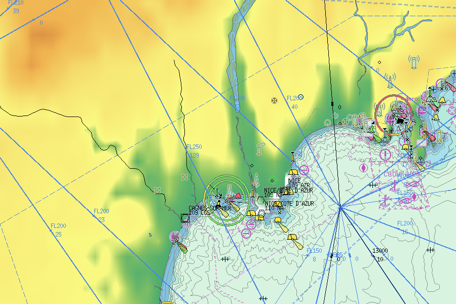
WMS ChartServer serves chart images using standard WMS requests. The introduction of extended WMS parameters allows a more flexible configuration of the chart image, e.g. switching lights, text etc. on/off, defining safety contour, object filters and chart rotation.
ECDIS like chart settings
Display Base
Display All
Display Standard, Safety contour = 10m
Display Standard, Safety contour = 15m
Chart Rotation
GIS like layer settings
Depths information
Navigational areas
Navigational aids
Cables and Pipes
Demo Client
The S-57 ENCs used in this service were downloaded from the NOAA website; it may be the case that they do not contain the latest data available from NOAA. By using this service you accept the User Agreement.
Full-screen view / Download demo
WMS ChartServer Flyer
ChartWorld, an affiliated company of SevenCs, as a leading digital-navigation service provider for the maritime industry, offers an advanced web solution based on SevenCs WMS ChartServer, called ChartWorld Hosting Services. ChartWorld Hosting Services provides access to a worldwide chart database, always up to date, accessible from every point of the globe. Read more...